

Cyclone Akvan Likely to Form Today: Third Storm in Three Weeks After Arnab and Murasu Raises Concerns Over Bay of Bengal
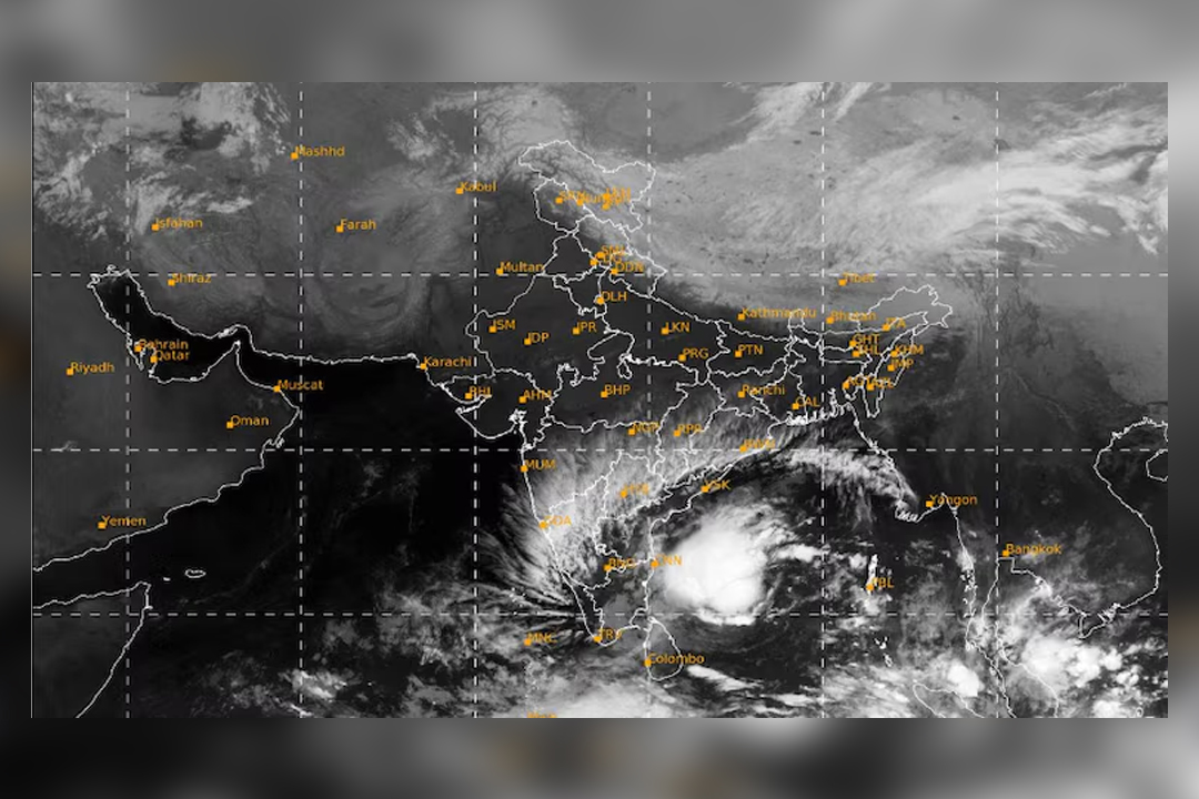
Why is the Bay of Bengal witnessing repeated cyclonic activity? A developing low-pressure system over the southeast and southwest Bay of Bengal is gathering strength and is expected to intensify into a cyclonic storm on Monday. It could further strengthen into a very severe cyclonic storm over the next four days, according to meteorologists.
Just two weeks after Cyclone Murasu crossed the Andhra Pradesh coast near Ongole, another potential cyclone is developing over the Bay of Bengal. The new system could follow a similar path, raising concerns along the eastern coastline.
According to a special bulletin issued on Sunday by the Regional Meteorological Centre (RMC) in Kolkata, the low-pressure system over the southeast and southwest Bay of Bengal is gradually intensifying. It is expected to develop into a cyclonic storm on Monday and could become very severe in the following days.
Although its exact trajectory remains uncertain, meteorologists believe the system may move towards the Andhra Pradesh coast. If that happens, Andhra Pradesh could face its third cyclone in less than three weeks, following Cyclone Arnab on October 28 and Cyclone Murasu on November 2.
Once it develops into a cyclonic storm, the system will be named Akvan, a name proposed by Iran.
Cyclones over the North Indian Ocean are named on a rotational basis using a list of names contributed by countries in the region. Akvan is the next name in the sequence.
According to the weather forecast, the system is likely to move north-northwestwards while gradually gaining strength.
The expected development is as follows:
- November 16: Likely to intensify into a cyclonic storm over the central parts of the south Bay of Bengal and adjoining west-central Bay of Bengal.
- November 17: Expected to strengthen into a severe cyclonic storm over the west-central Bay of Bengal.
- November 19: May intensify into a very severe cyclonic storm, with sustained wind speeds of 120-130 kmph and gusts reaching up to 145 kmph.
If the forecast materialises, Cyclone Akvan could be stronger than Cyclone Murasu, which crossed the coast as a severe cyclonic storm with wind speeds of 100-110 kmph.
The developing cyclone could influence weather conditions in Kolkata and southern West Bengal from November 18, bringing light rainfall to several areas.
Rainfall may intensify on November 19 and 20, although heavy rainfall is not predicted at present. Coastal districts of southern West Bengal could receive relatively heavier showers. However, the exact intensity of rainfall will become clearer once the cyclone’s path is established.
The Regional Meteorological Centre has not issued any weather warnings for West Bengal until November 18. However, officials are closely monitoring the developing system. Its outer bands could influence weather conditions across the region later in the week.
The Bay of Bengal is among the world’s most cyclone-prone regions, with October to December being the peak period for cyclonic activity.
One of the major reasons is the high sea surface temperature during this period. Even after the withdrawal of the southwest monsoon, the sea remains warm, with temperatures often exceeding 28 degrees Celsius. Such warm ocean conditions provide the energy required for cyclones to develop and intensify.
At the same time, strong upper-level winds that can disrupt the formation of storms during the monsoon season tend to weaken. This creates favourable atmospheric conditions for low-pressure systems to organise and develop into cyclones.
The geographical shape of the Bay of Bengal also plays an important role. Surrounded by land on three sides, the Bay often guides cyclonic systems towards the coastal regions of Andhra Pradesh, Odisha, West Bengal and Bangladesh.
Back-to-back cyclones can occur when these favourable conditions persist for several weeks.
Although a passing cyclone generally cools the sea surface along its path by bringing colder water from deeper layers to the surface, the Bay of Bengal can regain its warmth relatively quickly. This allows fresh low-pressure systems to develop over nearby warmer waters.
Large-scale atmospheric patterns moving across tropical regions can also enhance cyclonic activity over the Bay for several weeks.
These combined oceanic and atmospheric conditions explain why cyclones sometimes develop in quick succession, as has been observed in the Bay of Bengal this season.